My Trans-Himalayan Odyssey - Lahaul, Spiti & Kinnaur : Part - 6 - Langza, Komik, Hikkim, Pin Valley & Kungri
- ashokkdas1958
- 1 day ago
- 9 min read
“This post continues the story from my previous post in the “My Himalayan Odyssey” series, which you can read at www.ghumnechalo.in”
(My Trans-Himalayan Odyssey - Part 5 : From Glacial Melts to the Fortress of Faith : Kunzum Pass, Chicham Bridge, Key Monastery, Rangrik & Kaza (https://www.ghumnechalo.in/post/my-trans-himalayan-odyssey-part-5-kunzum-pass-chicham-bridge-key-monastery-rangrik-kaza))
The Ocean in the Clouds: A Journey Through Spiti’s High Hamlets Langza, Komik, Hikkim, Pin Valley & Kungri
The Two Faces of the Golden Hour Rule: From Icy Passes to Barren Peaks
In my earlier posts covering the frozen peaks of Baralacha, Shinkula, Kunzum and Chandra Tal, I shared my 'Golden Hour Rule': start at dawn to outrun the sun. In those regions, an early start is a survival tactic to avoid the treacherous road slurry and flooded crossings caused by melting snow.
But as we pushed deeper into the Spiti hinterlands—heading toward the world’s highest post office and the ancient 'Fossil Village'—the snow began to vanish. You might think the rule would become obsolete, but it remained our most valuable strategy for two new reasons. First, since the region was just waking up from its winter hibernation, most eateries were still shuttered; returning to Kaza by lunch was a practical necessity. Second and more importantly, afternoons in the harsh terrains are brutal. As the day progresses, the temperature drop and freezing gusts, descending from the surrounding peaks, turn the terrain into a hostile environment for travelers. Between the biting cold and the occasional blinding dust storms, it becomes a struggle just to stand outside for a few minutes. In Spiti, the early bird doesn’t just get the view—they escape the wind.
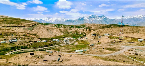
Leaving Kaza behind, we soon turned onto a dusty, punishingly steep track that climbed into Spiti’s high backcountry. We gained over 2,500 feet in just 10 kilometers, eventually leveling out on a high plateau at an altitude of 14,500 feet. As we traversed the highland, a tiny hamlet appeared in the distance across the valley. Drawing closer, we finally arrived at Langza, a quaint village nestled quietly against the mountain slope.
Langza : The Land of the Golden Buddha
Our journey along this high-altitude circuit begins in Langza, a place famously dubbed the "Fossil Village." Long before the cluster of traditional white-washed mud houses comes into view, the Langza Buddha commands your attention. Placed at the end of the village on the high ridge draped in vibrant prayer flags, this golden statue of Maitreya—the Future Buddha—gazes eternally across the valley with the majestic Chau Chau Kang Nilda peak, or the "Princess of the Sun and Dawn," as a dramatic, towering backdrop.


Standing at the feet of this massive golden figure, you are enveloped by that legendary Himalayan "stillness"—a sense of weightless peace that transforms the 16 km ascent from Kaza into a true pilgrimage. This serenity is only deepened by the local women lining the ridge; as they knit woolen gloves and mufflers and often selling small souvenirs and hot cups of tea, their warm smiles and gentle hospitality offer a humbling reminder of resilience amidst the rugged mountain landscape.


Walking on the Ocean Floor
At a staggering 14,435 ft, Langza offers a fascinating geological irony: this high-altitude "Fossil Village" was once the depths of the prehistoric Tethys Sea. It’s a surreal experience to stand amidst snow-capped peaks while walking on what was, millions of years ago, the ocean floor. Today, visitors can spend hours wandering through the high-altitude meadows "fossil hunting" for ammonites—locally known as Chaudua. These spiral-shaped relics date back 150 million years to the Jurassic period, serving as ancient, stony reminders of the earth's radical transformation from deep sea to Himalayan heights.
.
At 14,435 ft, Langza isn’t just a destination; it’s a high-altitude sanctuary where the ancient past and the spiritual present coexist in a profound, wind-swept silence.
Komik: The World’s Highest Motorable Village
Leaving the Golden Buddha’s blessings and the warm smiles of Langza behind, we moved on to Komik. Perched at an impressive 15,050 feet, it holds the title of the world's highest village accessible by road. Though even smaller than Langza, this tiny settlement is home to the renowned 14th-century Tangyud Monastery, also known as the Komic Gompa, a monastery that strictly upholds its ancient traditions.


Tangyud Monastery: The Spiritual Fortress
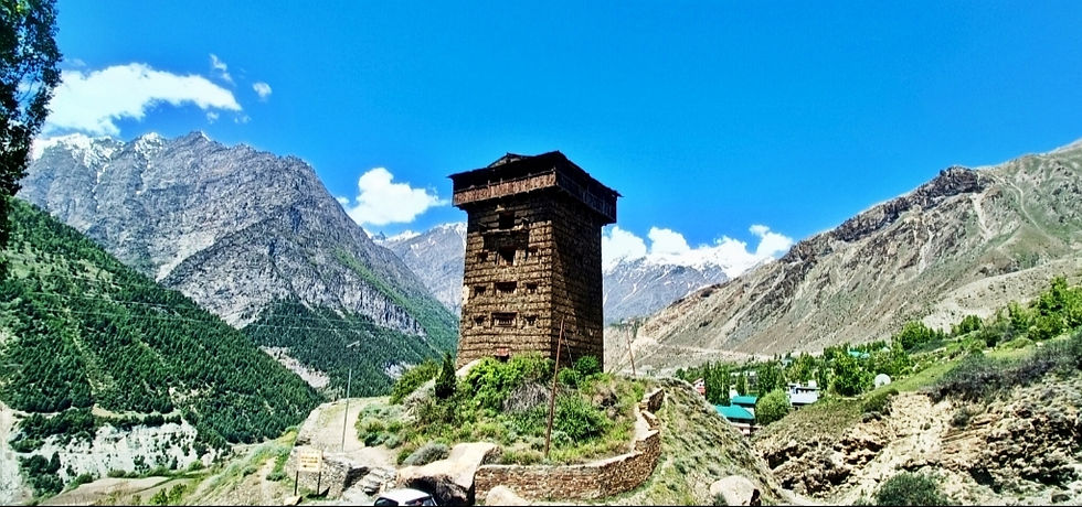
High at the village entrance, the ancient Komic Gompa resembles a fortified castle, its slanted mud walls standing as a testament to one of India’s highest and oldest spiritual retreats. Inside, the monastery is guarded by a statue of the Maitreya Buddha, the village’s revered protector. The atmosphere is thick with the scent of aged manuscripts and burning juniper incense. Despite the brutal isolation—where winter temperatures can plummet to -30°C—the resident monks greet visitors with warm smiles and local lore. Perhaps the most striking feature is the stuffed snow leopard hanging at the entrance, serving as a haunting, silent guardian of the rugged Spitian wilderness.


Just a short walk away lies a vital sanctuary: a café claiming the title of the world’s highest restaurant, offering a literal oasis of warmth in the middle of the high-altitude cold desert.

A Letter from the Clouds: A Journey to Hikkim
A short, winding drive took us to Hikkim, a village perched at roughly 14,567 feet and home to the world’s highest functional post office. Since its establishment in 1983, this mountain outpost has served as a vital lifeline for the isolated community; it also holds the distinction of being India’s highest polling station.


The post office recently shed its humble mud-brick structure in the narrow dirt paths of the village for a playful transformation. It is now a vibrant red structure shaped like a giant letterbox, standing in whimsical defiance of the muted browns and greys of the Spiti Valley landscape.

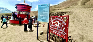


Buying a postcard, licking a stamp that won't quite stick in the dry air, and sending a note to a loved one has become the ritual for the visitors. Even with the uncertainty of delivery, there is a profound, old-world romance in sending a postcard from the roof of the world—a slow-motion alternative to the frantic pace of the 5G era.
High-Altitude Resilience: Life in the Spiti Valley
Traveling through Spiti Valley feels like traversing the floor of a dried-up ocean relocated to the heavens. While the entire circuit is breathtaking, the trio of Langza, Hikkim, and Komik—perched high above Kaza—offers a glimpse into a world where time seems to have frozen.
Despite our resolve to return to the sanctuary of Kaza by lunchtime, we couldn't suppress our enthusiasm for meeting the local villagers. We chose to brave the harsher afternoon for a deeper insight into their lives—a decision that only compounded our respect for their incredible resilience.
A Community Against the Elements
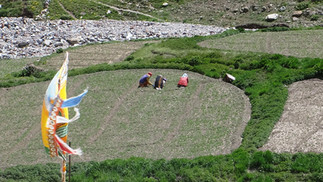
Though located only 15–16 km from Kaza, these villages with population ranging from 110 to 150 remain isolated from the outside world for six to seven months each winter. Life here is a masterclass in survival, centered entirely on agriculture and livestock.
At an altitude of 14,000 feet, farming is a frantic race against time. The "cold desert" conditions offer only a single, condensed growing season from May to September. Despite dry soil and scarce organic matter, the community has perfected high-altitude farming. They focus on hardy staples like green peas, barley, black peas, and potatoes, while experimenting with spinach, radish, and onion greens during the peak summer heat.
The Ingenuity of the "Kuls"
As this region sits in a rain shadow zone, rainfall is virtually non-existent. Farming depends entirely on glacial meltwater from the Chau Chau Kang Nilda peak. The villagers utilize an ingenious traditional system of "Kuls"—long, gravity-fed channels that divert snowmelt to the fields.
Because water is so precious, it is managed via the "Chu-rey" (water turns) system. A village committee, often led by the local women, ensures that every household receives an equitable share of water at designated times.
The Symbiosis of Livestock and Land
Livestock serves as the backbone of the agricultural cycle. Hardy Yaks and Churus are used to plough the rugged terrain; during the labor, farmers often chant the Om Mani Padme Hum mantra as a gesture of gratitude to the animals. In a region where chemical fertilizers are rarely used, animal manure provides the primary source of nutrients, making the local produce organic by default.
Preparing for the Deep Freeze
As summer wanes, the focus shifts entirely to winter preparation. A significant portion of late-summer activity involves harvesting and stacking wild grass and crop residues. This stockpile is the only thing that keeps their sheep, goats, and yaks alive during the four to five months when the village is buried deep under the snow.
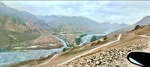
By the time we turned back toward Kaza, the afternoon was well underway and biting winds had picked up. We managed a brief stop at a scenic viewpoint overlooking the Spiti River’s confluence with its tributary flowing down from Chau Chau Kang Nilda Mountain, but the gusts were relentless. Forced to cut our break short, we hurried down the mountain toward the shelter and comfort of Kaza.


Gateway to the Wild: Entering the Pin Valley National Park
UNESCO, under its Man and the Biosphere (MAB) Programme, declared Spiti Region, India’s first Cold Desert Biosphere Reserve in September 2025. This high-altitude, cold desert ecosystem is celebrated for protecting endangered species like the snow leopard and Siberian ibex. The biosphere reserve includes the Pin Valley National Park, Kibber Wildlife Sanctuary, Chandratal Wetland, and Sarchu Plains. And our next destination was Pin Valley, the only National Park located within this Cold Desert Biosphere Reserve.
Leaving the stark, high-altitude desert of Kaza for the Pin Valley is like transitioning from a landscape of wide-angle grandeur to one of intimate, jagged drama. The journey into Pin Valley—the "Land of Ibex and Snow Leopards"- is a masterclass in Himalayan geology and Spitian heritage.
The Geological Gateway: Leaving the Spiti River
Driving south from Kaza and crossing the Spiti River via the Attargo Bridge, you witness a dramatic geological shift. This area serves as a natural laboratory where the Tethys Himalaya are laid bare. The mountain faces reveal sedimentary layers that have been violently warped into massive U-shaped synclines and arch-like anticlines—vivid evidence of the tectonic collision between the Indian and Eurasian plates.


Just upstream from the bridge, the vibrant turquoise of the Spiti River merges with the silt-laden, muddy waters of the Pin River. Passing this threshold feels like entering another world. The valley tightens, and the landscape sheds the dusty ochre typical of Spiti, replaced by a striking palette of deep purples, maroons, and greens. These vivid hues are the result of mineral-rich phyllites and schists surfacing in the rock.
The Engineering Lifeline: Chhidang Bridge
Moving further into the valley, we reached the Pin River Bridge at Chhidang, a vital landmark that serves as both a crossing and a spectacular lookout. From the bridge, the Pin River reveals itself as a braided stream, its waters splitting into a complex web of shallow channels that snake through a vast, stony basin.


The landscape here is a masterclass in mountain erosion. The valley walls are heavily weathered, marked by massive alluvial fans—broad, triangular piles of rock and sediment. These fans stretch from the cliff bases down to the water, offering a clear visual of how gravity and seasonal snowmelt are gradually carving away the Himalayan peaks.


Kungri: The Spiritual Heart of Pin Valley
A short trek uphill from the main road brings you to Kungri, a tranquil village of about 250 residents. Perched beside the Pin River, it houses one of Spiti Valley's most vital cultural treasures: the Kungri Monastery. Founded around 1330 AD, it holds the distinction of being the only Nyingma sect monastery in the region.

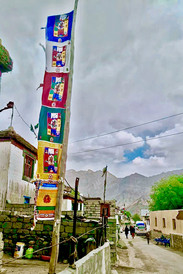


The Monastery Complex offers a striking contrast between eras: the ancient section - Weathered, mud-plastered prayer halls that whisper of centuries past, and the new structure - A grand, vibrant edifice adorned with vivid statues and meticulously detailed silk thangkas. While landmarks like Key, Dhankar or Tabo draw the crowds, Kungri remains a serene center of learning. It serves as a sanctuary for unique tantric traditions and the legendary Buchen dance. During our visit, the usual quiet was replaced by a focused energy, as the monks were deep in preparation for an upcoming festival.


The Road to Mud and the final destination
The final approach to Mud Village is a visual masterpiece. As the road traces the river’s edge, the mountains tighten around you, showcasing dramatic rock faces streaked with vivid minerals. Against the dull gray limestone, vertical veins of fiery iron red and copper green pop with intensity, especially as the late afternoon sun hits them. The valley also takes on a sharp U-shaped silhouette—a striking geological fingerprint left behind by the ancient glaciers that once tore through this landscape.


Perched on a high river terrace at an elevation of approximately 12,500 feet, Mud is the final inhabited village of the Pin Valley. It serves as the primary gateway for trekkers tackling the Pin-Parvati and Bhaba Passes.
From the village square, visitors are treated to a panoramic view of the "Pin-Spires"—a series of jagged, vertical peaks that resemble stone Gothic cathedrals. The village itself is a cluster of traditional whitewashed homes with distinctive red-trimmed windows, built closely together to endure the region’s harsh winters. The visual contrast is striking: the bright white architecture stands out vividly against the deep, moody purple of the surrounding scree slopes.


Beyond Kaza: Deeper Into the Spiritual Heart
As the shadows lengthened and the jagged "Pin-Spires" stretched across the valley floor, we began our retreat to Kaza. These past two days have been a revelation—from the prehistoric fossils of Langza and the iconic red letterbox of Hikkim to the mineral-painted, cathedral-like peaks of Mud.
Spiti has shown us that it is more than a mere destination; it is a living testament to persistence. In this high-altitude desert, where tectonic forces once thrust an ancient ocean floor into the clouds, life does not just survive—it flourishes through a soulful, delicate dance with a formidable environment.
But our journey is far from over. Spiti is not a place you simply "visit"; it is a landscape you endure until, inevitably, you fall in love with it. Our path now leads us deeper into the spiritual heart of the mountains: the ancient monasteries of Dhankar, Tabo, and Gue, before we cross into the Kinnaur region to find the timeless village of Nako.
"Loved this read? Head over to www.ghumnechalo.in for more travel stories and hidden gems!"


Comments